|
Advanced NavigationSM |
||||||||||||||||
|
Students Per Instructor: 1, 2 or 3
Course Summary: This course will teach you how to efficiently incorporate the latest reliable technology into your outdoor adventures. We present methods for integrating computer-based mapping, aerial photography, and GPS with traditional tools, to enable you to better plan and execute your adventures. |
||||||||||||||||
|
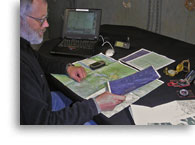
Course Description: Like a photographer who can’t get the camera adjusted before the subject flees or falls asleep, a navigator whose tools are awkward and slow, will wear down companions’ patience. All too often these people are distracted by “features” that get in the way of useful information – and enjoyable experiences. For many years, we relied on traditional navigation tools and techniques exclusively. We still depend upon traditional tools for backup, but we have embraced (and cursed) modern navigation technology as well. The key to using this technology is to develop simple, streamlined practices that accomplish the task without getting bogged down with minutae. These are the methods we teach in this couse. The other key is to limit your choices to well thought-out, robust hardware and software. We start by showing you where to find detailed maps and aerial photos (for most of the world) on the internet, and how to utilize this information once downloaded to your computer. Next, we spend some time looking at portable GPS units, and how to calibrate and use them efficiently in conjunction with a voice recorder to describe waypoints meaningfully. We present several options for computer-based mapping on Macs, PC’s and handhelds. We also look at various methods for manipulating and transporting this information practically, and some of the software that does it well. And, we discuss how to move data between a portable GPS unit and a computer; and what to do with it once it gets where it’s going. Most importantly, once we have introduced all of this technology, we take it out and show you exactly how it works in the real world. A clear understanding of traditional navigation tools and techniques is an essential prerequisite for this course. Familiarity with basic GPS usage is also helpful. Our Basic Navigation course teaches these skills. We continue to investigate new tools and develop new methods so we can take advantage of recent advances in technology and share them with students. We can easily focus on any particular aspect of navigation you find important or interesting. |
|
||||||||||||||||
|
~ Mountain Adventures In the Adirondacks Since 1985 ~ |
|||
|
Alpine Adventures, Inc. |
(518) 576-9881 |
||


